

Home > Off the Charts > Uneven State of the Union
Spread of COVID-19 Hotspots across Rural America
Even as COVID-19 cases continue to increase in the United States, reaching over 1.67 million cases and nearly 100,000 deaths as of May 26, 2020, many states are now beginning to ease social distancing and stay-at-home mandates. Each state is taking its own unique approach to lifting stay at home orders, allowing businesses to open, and loosening social distancing regulations, due in no small part to a lack of direction from the federal government.


Key Observations and Insights
At the beginning of March, 22 of the top 25 COVID-19 county hotspots were in urban areas. However, by the end of May, 65% of the top hotspots were in rural counties with vulnerable populations, concentrated in meatpacking or dairy plants, prisons, and nursing homes – places where social distancing opportunities are limited.
While the COVID-19 pandemic continues on a stubborn trajectory across the country, its path has been uneven across rural and urban counties. State and city governments followed divergent social distancing and stay-at-home mandates with varying impacts on reducing infection rates (Rt).
Following our analysis on how US states differ in slowing COVID-19, we took a deep dive at the county level to examine COVID-19 hotpots across a rural-urban continuum, where hotspots are defined as number of cases per resident. We investigated how these epicentres emerged and cases spread across rural counties; determined, among other factors, by the nature of economic activity, population density, and demographics.
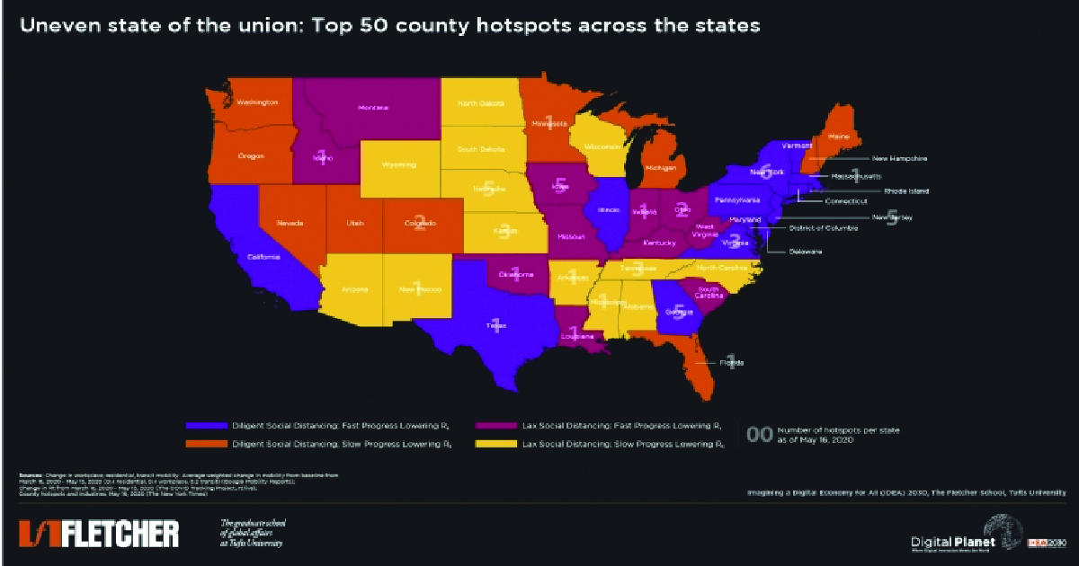
We first looked at the top 50 county hotspots across states, in accordance with change in mobility and Rt taxonomy.
New York and New Jersey, with populous, dense urban counties, did have some of the highest number of hotspots, despite diligent social distancing policies. However, on a per capita basis, rural counties in Nebraska, Tennessee, Kansas, and Arkansas find themselves at the top of the hotspot list. While these states did not follow strict social distancing policies, that alone does not explain the hotspot outbreaks since states with similar lax policies (such as South Carolina and West Virginia) did not report any county hotspots. Sparsely populated small towns and rural communities in the Midwest and South also emerged as top hotspots due to cluster outbreaks.
In Trousdale County, Tennessee, 1 in every 7 people had tested positive for COVID-19; in Nobles County, Minnesota, it was 1 in every 16 people; and in Colfax County, Nebraska, 1 in every 21 people. Admittedly, several of these hotspots are in states which followed lax social distancing, but it is key to note that these outbreaks were part of clusters where social distancing opportunities were limited – meatpacking plants, correctional facilities, and nursing homes
Not only are these outbreak clusters all found in places where people are tightly packed together, they also ravaged through nursing homes with highly vulnerable populations. To date, more than 222,000 people in nursing homes and long-term care facilities, and at least 56,000 people in American jails and prisons, have been infected. Out of the top 50 county hotspots, 17 cases originated in meatpacking plants and then spread to the community with abandon. In non-metro areas meatpacking plants are central to employment opportunities, thus an outbreak can impact a significant proportion of the community directly or indirectly associated with these plants.
In South West Kansas such plants provide 27.1 jobs per 1000, in North East Alabama 14.2 jobs per 1000, as compared to 0.8 jobs per 1000 in slaughterhouses in Chicago. Counties such as Ford and Finney in Kansas, Hall in Nebraska, and Woodbury in Iowa, account for anywhere between 12-15% of the total positive cases in their respective states. Long hours working shoulder to shoulder in cramped confines make meat and poultry processing plants an ideal ground for transmission of the virus – a CDC report found nearly 5000 COVID-19 positive cases across meat and poultry processing plants in 19 states.
To epidemiologists, the spread of the virus across rural America wasn’t a question of if, but when, with two early warning signs emerging from a ski resort in Idaho and a funeral in Georgia. Analysis of the clusters across counties shows that the rural hotspots were also some of the most socially vulnerable – with populations that couldn’t afford to socially distance, few hospital beds and healthcare professionals, and an older demographic.
Considering county level hotspots and clusters in conjunction with social distancing mandates presents an evolving picture of how such policies might be effective in urban, densely populated areas, which may also have higher per capita access to health services and the ability to continue employment in a socially distant environment. However, as the virus continues to spread across rural America, social distancing alone will not be sufficient given that a significant proportion of the population cannot afford to follow such measures. Additionally, with the realities of demographic factors like age, income, and occupation, existing comorbid conditions, as well as the state of public health infrastructure in many rural counties, a case that may emerge unwittingly has a high likelihood of unabated spread in areas with limited capacity to test, treat, and control.
Research Methodology
COVID-19 Hotspots
Hotspots were computed as a ratio of confirmed positive cases by county population. The dataset on county level confirmed cases and population until May 20, 2020 was obtained from USAFacts. The map shows the top 50 county hotspots as reported by the New York Times. Urban and rural classification of counties were based on the Rural Urban Continuum Codes (RUCC) by the USDA ERS, where counties with RUCC 1-3 were classified as urban and those with RUCC 4-9 were classified as rural.
COVID-19 Hotspots by Industry
Focal points of COVID-19 hotspots by industry were obtained from various news sites and the meatpacking plants COVID-19 county report by The Environmental Working Group (EWG). Two counties, namely Blaine County, Idaho and Terrell County, Georgia were included in the map under ‘Various/Other’ legend as the hotspots were clustered at a ski resort and funeral home, respectively. These two hotspots were not called out separately for purposes of clarity in interpreting the map (they were the only hotspots at a ski resort or funeral home during the examined time period).
All data and sources for the county hotspot data are available here.
All data and sources for the social distancing and Rt data are available here.
Former Digital Planet Graduate Analysts Malavika Krishnan, Madhuri Mukherjee, and Devyani Singh worked on this analysis under the guidance of Bhaskar Chakravorti, Ravi Shankar Chaturvedi, Christina Filipovic, and Joy Zhang at Digital Planet, The Fletcher School, Tufts University.


